She created Wander In Arizona to share first-hand information about traveling to the many fantastic cities, trails, national parks, monuments and more as she continues to explore.
If exploring Arizona National Monuments is one of your bucket list items, you are not alone.
After all, the Grand Canyon state and the wilderness with enchanting landmarks go together.
The recreational areas, national monuments, and national parks in Arizona are the treasure houses of the state’s spectacular landscapes.
Arizona national monuments encompass astounding scenery and nature, its massive areas of deserted landscapes home to sand and cactus, canyons, craters, ancient ruins and enduring legends, and many archaeological sites and settlements left behind by the Ancestral Puebloans.
Arizona is one of the few states in the United States with in-depth roots in Indian reservations prevalent to this day.
The rich Native American history, culture, and heritage have been able to thrive and be conserved thanks to the many national monuments in Arizona maintained by N.P.S., B.L.M., and a group of local authorities.
Whether you are a history lover wanting to get glimpses of the native history or an adventure seeker looking to explore the fascinating outdoors and wildlife in Arizona, this post details the best Arizona National monuments, what to expect, and helpful tips for planning your trips.
THINGS TO KNOW ABOUT ARIZONA NATIONAL MONUMENTS
Before looking into the best national monuments in AZ, let us understand a few facts, especially if you are a non-US traveler.
What is a National Monument?
Similar to US national parks, national monuments are federally protected lands or areas reserved by the Federal Government since they are categorised to be of nationally significant value for their natural or human monuments, sites and settlements of historic, prehistoric, or scientific importance.
The US president can only create national monuments through the Antiquities Act.
National Parks also come under national monuments.
Some examples of national monuments in Arizona include ancient cliff dwellings, archaeological ruins, unusual landscapes and rock formations.
How many National Monuments in Arizona are there?
Arizona has 18 sites designated as National Monuments, more than any other state in the USA. Apart from these monuments are historic sites, recreation areas, national lands and parks.
What is the difference between a National Park and a National Monument?
National parks are also categorised under national monuments, and they are areas set apart by the government of the US to be explored by its people.
But the main difference between them is that while national parks are massive, spanning thousands of acres and home to a diverse set of features ranging from wildlife to abundant landscapes, national monuments are generally smaller and each classified for its unique features.
Who looks after Arizona National Monuments?
The National Park Service generally manages Arizona National Monuments, but the Bureau of Land Management looks after a few.
WHAT IS THE BEST TIME TO VISIT ARIZONA NATIONAL MONUMENTS?
Arizona’s national monuments are busiest during summer, the peak tourist season and popular months. Summer is also too hot for many, and the presence of insects and poisonous animals outdoors is higher.
If you want lower prices and far fewer crowds, early Spring and fall are the best months to visit national monuments in Arizona.
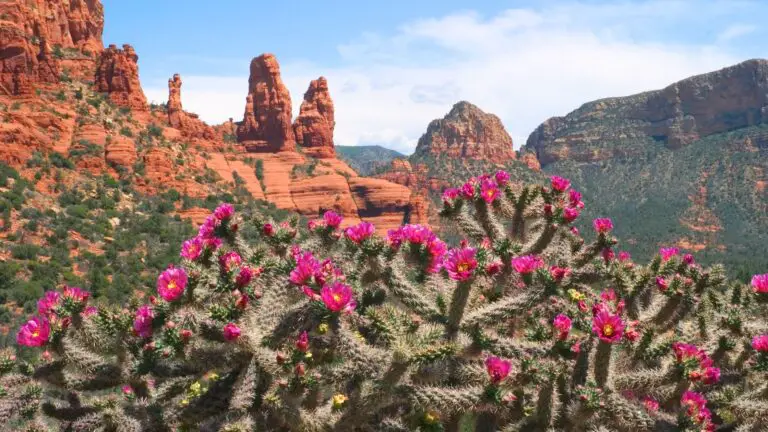
Spring is the best season for fascinating views of wildflowers transforming the arid landscapes colourful in Arizona national monuments.
The fall and winter months are perfect for hikes without the dangers of poisonous snakes, with incredible views of snow-carpeted landscapes and fewer tourists.
WHAT STATE HAS THE MOST NATIONAL MONUMENTS?
Arizona and California have the most national monuments, with 18 of them.
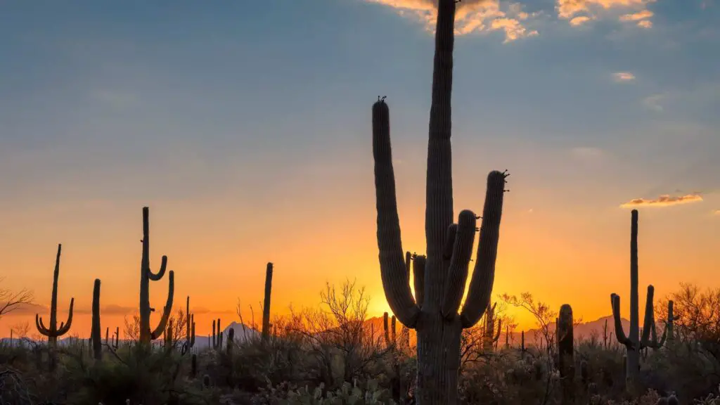
TOP ARIZONA NATIONAL MONUMENTS
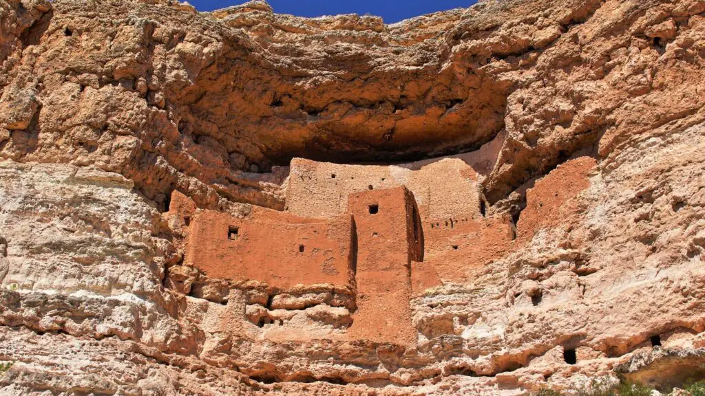
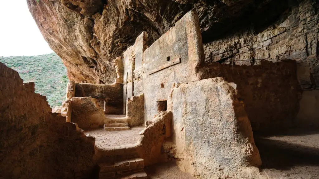
MONTEZUMA CASTLE NATIONAL MONUMENT, CAMP VERDE
- The nearest city – Sedona
- Famous for – Historic cliff dwelling
- Best time to visit –
- Facilities – Visitor Center, museum, restrooms
- Managed by – National Park Service
- Entry – Covered by the ticket to Sun Crater monument
One of the popular day trips from Sedona Montezuma Castle National Monument is among the most beautiful cliff dwellings in Arizona, located on the Colorado Plateau.
It is one of the best Arizona National Monuments if you are on a quest to explore the state’s best cliff dwellings or want to know the rich and ancient history of the Native Americans inhabiting the vast expanse of landscapes in the Grand Canyon state.
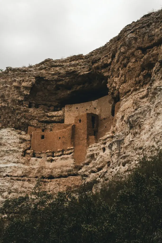
Castle National Monument is home to one of the most impressive and important archaeological sites in the States.
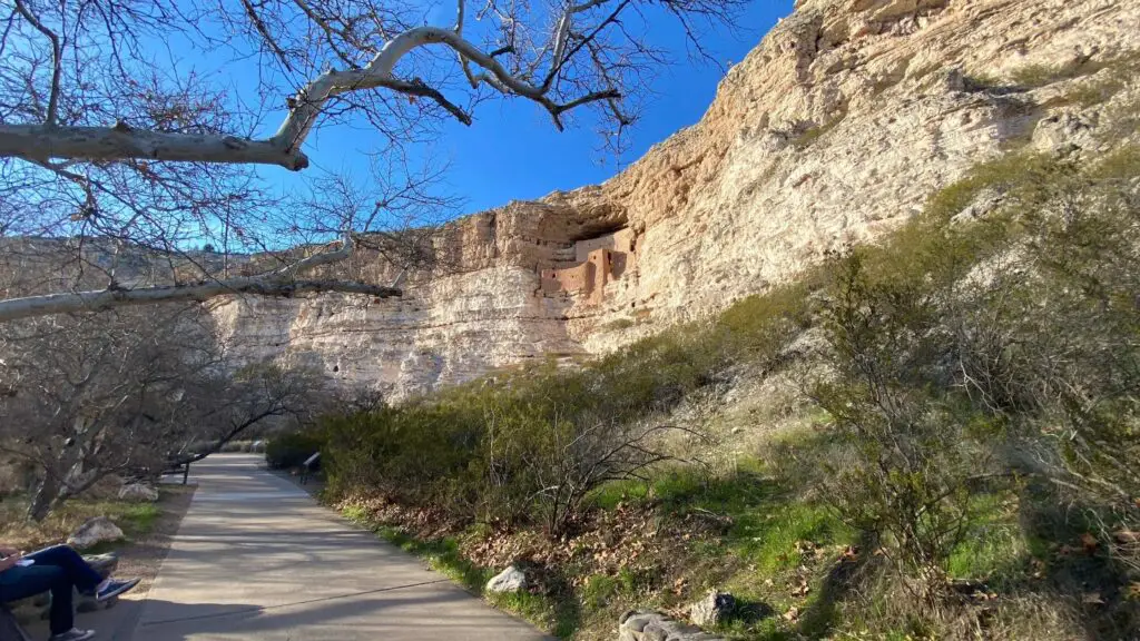
It is considered one of the largest and the best-preserved cliff dwellings in North America, the remains of an ancient settlement over 900 years old.
Located in Camp Verde town in the Verde Valley 25 miles south of Sedona, it was established in 1906 to preserve Indigenous American culture.
Although not related to the famous Aztec emperor, this compact structure is the most spectacular among all the national monuments in Arizona.
It comprises a 5-floor structure carved into a cliff 1,500 feet high above the ground in an alcove in the limestone cliffs bordering Beaver Creek, a tributary of the Verde River.
The inhabitants were the Sinagua people that existed here between 650 and 1425AD.
This cliffside complex was built around AD700 by the Sinagua people and abandoned in 1485 after a long drought.
A short pathway lined with sycamores and catclaw mimosa trees leads to the limestone cliff, which is a stunning and sophisticated example of Sinaguan architecture comprising 20 rooms in multiple stories reached by ladders, and also includes Montezuma Well, a flooded limestone sinkhole a few miles east.
RECOMMENDED – TOP 10 STUNNING CAVES IN SEDONA FOR OUTDOOR LOVERS
Made out of stone-and-mortar masonry, it is an example of exquisite engineering skills and ingenuity, whether it is the placement of rooms to take shelter from the scorching sun or its elevated location that provided protection from Beaver Creek’s annual flooding and to keep an eye on approaching visitors.
While you can’t enter the building during a visit to protect its delicate features, today, you can access Montezuma Castle by a paved third-of-a-mile trail leading to a viewing point below the ruins.
The route has shade, thanks to large trees and passes beneath the cliff dwellings and then loops back to the visitor centre.
You can learn about the pre-Columbian site at its museum to imagine life in this unforgiving desert landscape.
Along the way to the viewing point, there are informative exhibits about the region and its inhabitants.
After touring this stunning castle, drive 11 miles north to see the Montezuma Well, also part of the national monument.
An unusual spring-fed travertine pool in the middle of the arid desert, it is a unique geological feature that once provided water for Sinaguan communities.
After arriving at the trailhead, take the short hike to the lookout to see down into the deep waters below.
The water in the well today, which is about 400 feet deep, has high levels of arsenic and other chemicals.
Continuing along the trail will lead to an ancient but still functioning canal system, along with a large shaded area. Here, you can see smaller dwellings and the remains of an irrigation system.
WALNUT CANYON NATIONAL MONUMENT, FLAGSTAFF
- The nearest city – Flagstaff
- Famous for – Ancient historic cliff dwellings
- Best time to visit – Spring and Fall
- Facilities – Visitor Center, bookstore, museum, restrooms
- Managed by – National Park Service
- Entry – $15 per person
If you are looking for fantastic day trips from Flagstaff that you can easily access, head to Walnut Canyon National Monument, located east of the city.
It is one of the famous Arizona National Monuments known for its historic ancient cliff dwellings and many fabulous hiking trails, offering plenty of outdoor activities for adventure seekers.
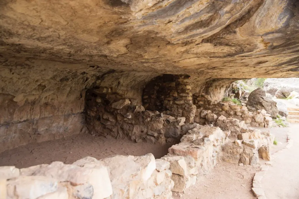
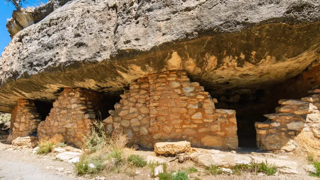
A 600-foot-deep gorge is home to more than 300 gorgeous Sinagua Indian cliff dwelling ruins from 1120 AD.
These fascinating multi-room dwellings in protected alcoves high in the canyon walls are well-preserved examples of their marvellous engineering and architectural skills.
The site was abandoned, possibly due to drought or tribal warfare.
Walnut Canyon National Monument was established in 1915 to help protect the sites and conserve the cliff dwellings.
Walnut Canyon is known for its distinct and beautiful white Kaibab limestone formations, amidst which you will find many of these fantastic cliff dwellings, which were forme family homes overhanging on the ledges of the canyons.
These single-family dwellings are visible from the Visitor Center, and hiking is the best way to experience the cliff dwellings at Walnut Canyon National Monument.
The Island Trail, a one-mile trail, beginning at the visitor centre, descending 185 feet into the canyon and comprising over 700 stairs, winds its way past 25 ancient dwellings.
From the foot of the stairs, follow the trail to one of the simple pueblos and step inside.
You will see the fantastic windows and doors of ancient dwellings tucked between uneven rock layers, examples of simple yet brilliant masonry skills.
Look down to see the beautiful Walnut Creek, the water source for the residents, flowing to the east to join the Colorado River, which eventually flows through the Grand Canyon.
If you want a more accessible trail, the Rim Trail, a 0.7-mile round-trip flat trail, which passes by a partially rebuilt pueblo and a pit house, offers excellent views of the canyon and the ancient dwellings on the far side.
Although the park is open year-round, it snows and gets colder in the winter.
Check out the museum on the premises to learn about the pre-Columbian culture and the Sinagua people.
There are no camping or lodging facilities within the park, but camping is available in the surrounding Kaibab and Coconino national forests.
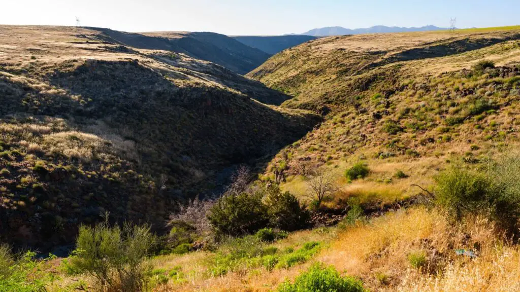
CHIRICAHUA NATIONAL MONUMENT
- The nearest city – Tucson
- Famous for – Ancient rock formations
- Best time to visit – Spring
- Facilities – Visitor Center, museum, restrooms
- Managed by – National Park Service
- Entry – No entry fee
One of the most popular day trips from Tucson, the Chiricahua National Monument is one of the best Arizona National Monuments known for its unique geological natural wonders, abundant wildlife and rugged landscapes.
Located in the Chiricahua Mountains of southeastern Arizona, the monument was established in 1924 and is home to stunning volcanic rocks that form pinnacles, hoodoos and narrow canyons, unusual plant species, unique wildlife, beautiful drives and paved hiking trails.
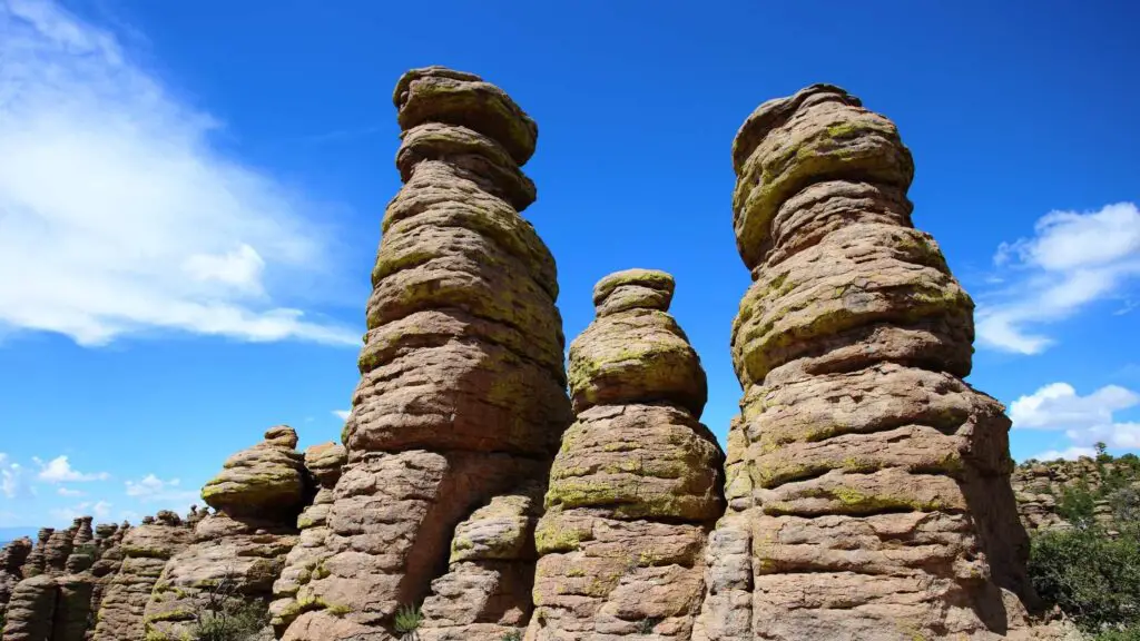
If you love rocks, Chiricahua is your kind of place. The large park spread over 12,025 acres of wilderness, with its two unofficial names, the Wonderland of Rocks and the Land of Standing Up Rocks, tell you why it’s one of Arizona’s most popular hiking destinations.
Twenty-seven million years ago, ash from the volcanic eruption nearby Turkey creek compacted into rock, creating a thick layer of rhyolite.
They got eroded and fissured, shaped and sculpted over the millennia by the wind and rain, forming fascinating rock formations into towering rock needles, with their stunning hoodoos making for spectacular sights.
These precariously balanced rock towers have colourful names today, like Grottoes, Wall Street, and Big Balanced Rock, accessed via many hiking trails and drives.
You can also find many excellent pinnacles and natural bridges beside balancing boulders and rugged volcanic rocks.
RECOMMENDED – TOP 10 SUNSET SPOTS IN SEDONA YOU SHOULD NOT MISS
Once a haven for the Chiricahua Apaches, the monument is a paradise today for hikers, outdoor lovers, adventure seekers and photographers.
Its location and limited access mean that only a few people visit, so if you want to camp under the stars with fewer or no crowds, you will love your trip to Chiricahua.
The park, home to many wildlife and plant species only found in this monument, has 17 miles of hiking trails and an 8-mile paved scenic drive.
through the national monument at a 6,500-ft high Massai Point, overlooking the gorgeous pinnacles, wildlife, plant species and rare cacti.
Popular hiking trails include Echo Canyon, the Upper and Lower Rhyolite canyons, and the Heart of Rocks Loop.
The 3.3-mile Echo Canyon Loop trail is more straightforward and can be done in a few hours, taking you to the heart of the rock formations, including Wallstreet, the Grottoes, and Echo Park.
If you are game for an adventurous and challenging hike, the 9.5-mile Big Loop covers all the main attractions, including the Echo Canyon, Upper Rhyolite Canyon, Sarah Deming, Heart of Rocks, Big Balanced Rock, Inspiration Point, and Ed Riggs trails.
If birdwatching or wildlife viewing interests you, get on the Bonita Creek Trail to spot deer, coatimundis, and migrating birds.
If you’d like to spend more time here, camping is one of the best options to explore more of Chiricahua National Monument and enjoy stunning stargazing. There is a campground with 25 sites and a group site surrounded by beautiful landscapes.
Visit Faraway Ranch Historic District on the east side of the park to join their weekend tours to learn about the pioneer life in this brutal landscape.
The park is open year-round, and summer is bearable, although not the best time to be here. There is occasional snow in the winter.
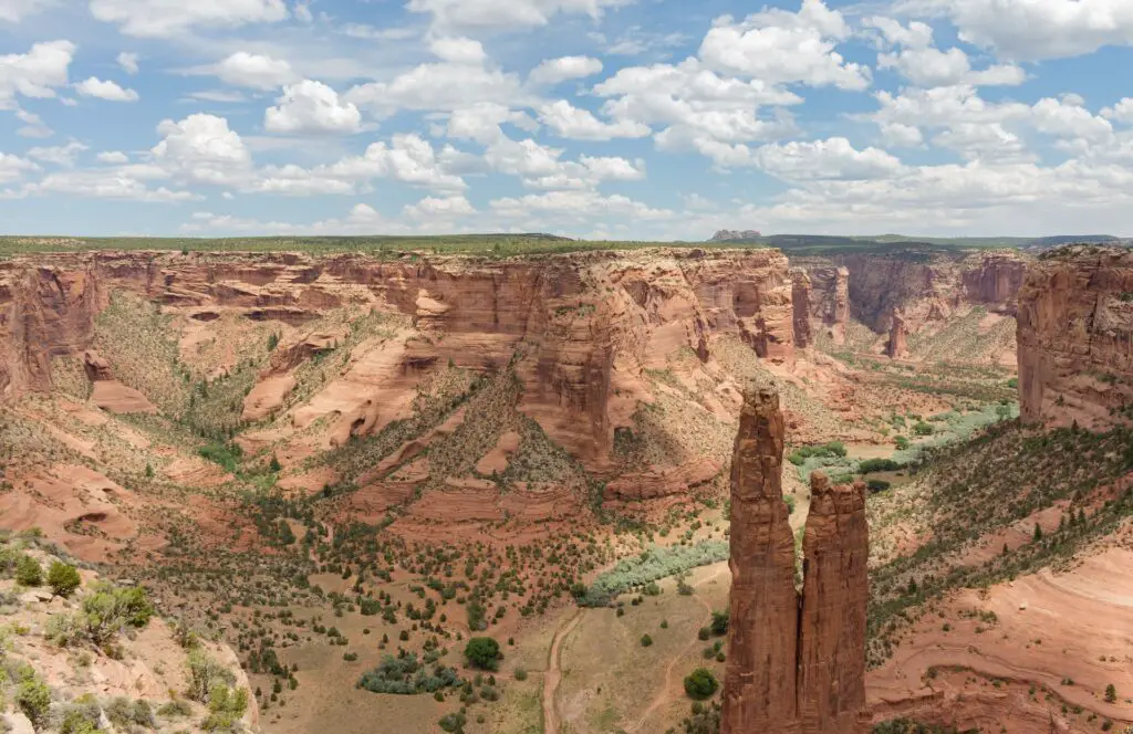
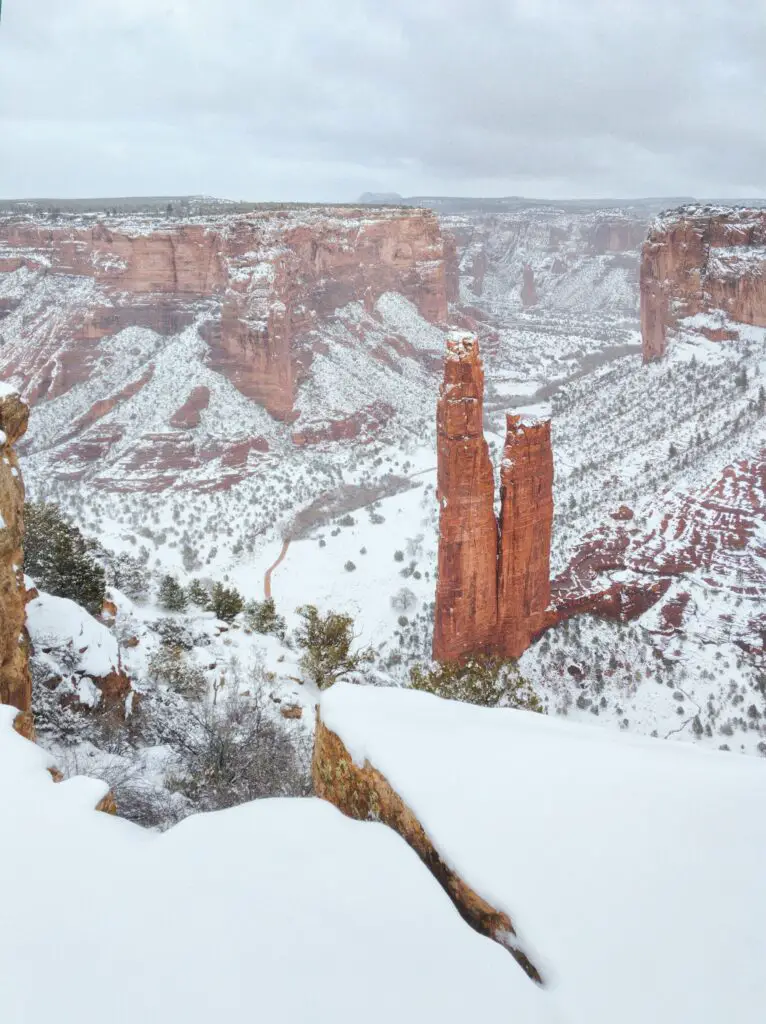
CANYON DE CHELLY NATIONAL MONUMENT, CHINLE
- The nearest city – Holbrook
- Famous for – Navajo and ancient Pueblo culture
- Best time to visit – Fall and spring
- Facilities – Visitor Center, restrooms, guided tours
- Managed by – National Park Service & the Navajo Nation
- Entry – Free entry
If you drive north of Interstate 40 towards Canyon de Chelly and continue passing through the lonely lands up South Rim Drive, you will arrive at Canyon de Chelly National Monument, one of the spectacular Arizona National Monuments that should be on your bucket list.
Located in northeast Arizona and part of the Navajo Nation, Canyon de Chelly National Monument encompasses magnificent red sandstone canyons created by Chinle Creek and its tributaries and ancient cliff dwellings high up in the walls along the ledges of the cliffs.
Canyon de Chelly National Monument in northern Arizona near the New Mexico border was established in the 1930s to conserve vulnerable archaeological sites and artefacts.
Although administered by the National Park Service (NPS), it is located entirely within the Navajo tribal homeland.
Carved into the sandstone bedrock of north-eastern Arizona, near Chinle, the three spectacular canyons, De Chelly, Del Muerto, and Monument, lie at the centre of the Navajo Nation and the heart of many native legends.
There are over 800 ancient archaeological sites between Monument Canyon, Canyon de Chelly, and Canyon del Muerto.
These canyons have been occupied by Indigenous peoples for 5,000 years uninterrupted, more continuously than anywhere in North America;
Before them, the sites were home to the Ancestral Puebloans, Anasazi, Hopi and Navajo around 2,500 BCE, as indicated by the remains of prehistoric petroglyphs and age-old edifices.
Forty families still live within the park’s boundaries even today.
Since the Navajo still call Canyon De Chelly their home and a sacred site, you can only explore the monument on a guided Navajo tour with a native or National Park Service rangers.
Two panoramic drives run along the north and south rims of the canyon and have many overlooks.
You can opt for guided driving tours like this one and stop at lookouts to cover many of the site’s attractions, including Mummy Cave, carved into the sheer cliff, and Antelope House, standing at the base of the canyon walls.
Don’t miss the fabulous, towering tall spire Spider Rock, an iconic sandstone spire that towers 230m above the canyon floor and, in Navajo legend, is the home of Spider Woman.
To see more, you’ll need to hire a native guide to escort you on either foot, 4×4 or horseback.
Half-day tours traverse the rough river bottom and are best to experience ancient ruins, caves, and petroglyphs up close.
If you don’t have time for a tour and are up for a relatively challenging hike, do the only self-guided walk, the 3-mile White House Trail, going 600 feet down into the canyon to arrive at the spectacular White House ruins.
The trail begins six miles east of the visitor centre along the South Rim drive.
In the 1800s, this canyon was the site of many massacres of Native Americans by the Spanish and US Armies.
Head to the Cottonwood campsite for tent and RV camping.
You need to book guided tours in advance at the visitor centre. The park is open year-round, but access may be limited in the winter due to snow.
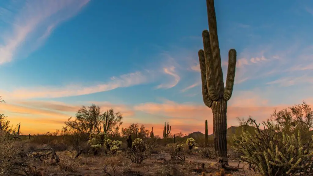
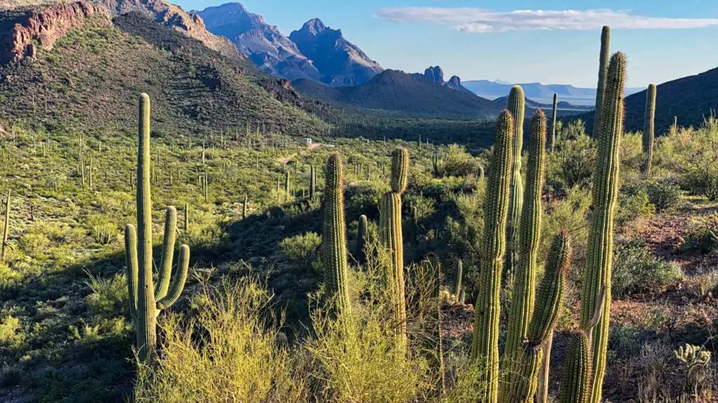
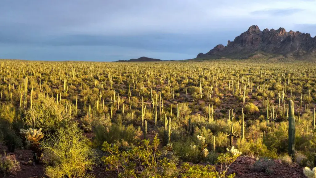
SONORAN DESERT NATIONAL MONUMENT
- The nearest city – Phoenix
- Famous for – Native history, camping, and remote desert landscapes
- Best time to visit – Spring
- Facilities – Limited. Carry lots of water(no water on the site) and snacks
- Managed by – The Bureau of Land Management
One of the largest deserts in the United States is the Sonoran Desert spanning Mexico and the US, and covering many states.
Considered the hottest desert in the country, it may not be your travel destination.
One of the best ways to get to know bits of this massive desert is by visiting the Sonoran Desert National Monument, one of the best Arizona National Monuments.
It is a fascinating National Monument in Arizona where you can enjoy camping, hiking, and also hunting if you are up to it.
This monument is located south of Goodyear and Buckeye and east of Gila Bend in South Central Arizona.
The Sonoran Desert National Monument is 55 miles southwest of Phoenix and is one of the popular day trips from Phoenix for many outdoor lovers.
It was established to conserve the desert’s rich history and natural abundance, including its wildlife and plants.
It is managed by the US Bureau of Land Management as part of the National Landscape Conservation System.
The site, home to half a million acres of cactus forests and secluded mountain ranges, including the Maricopa Mountains, the Table Top and Sand Tank ranges, preserves the Indian relics and native habitats of the Indigenous people.
There are roads within the monument that you can drive through to explore.
You can also explore the landscapes on horseback following the paved ways.
The monument is home to various wildlife, including desert bighorn sheep, mountain lions, mule deer and javelina.
Due to the remote location of the monument, there is no drinking water or basic facilities. If you want to hike or go biking, spring, fall and winter are better months.
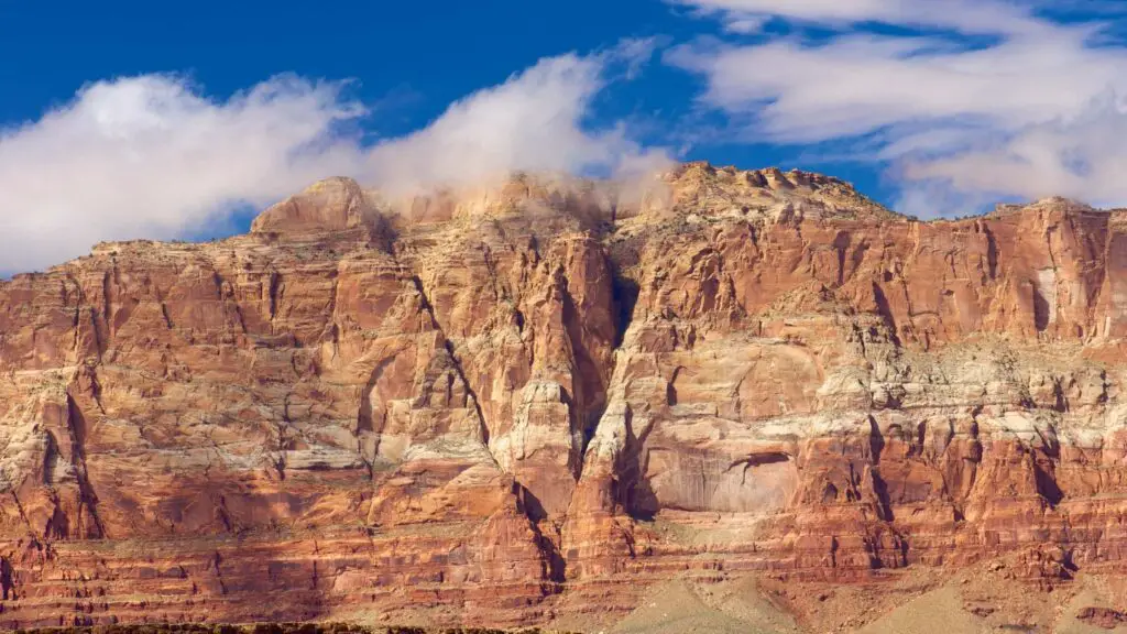
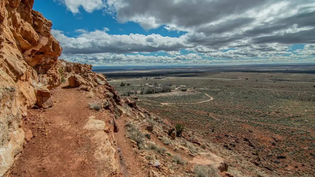
VERMILION CLIFFS NATIONAL MONUMENT
- The nearest city – Flagstaff
- Famous for – Stunning rock formations
- Best time to visit – Fall
- Facilities – None. Carry water and food
- Managed by – The Bureau of Land Management
- Entry – $10 per person
If you’re visiting the North Rim of the Grand Canyon, stop at this beautiful national monument near Page to admire the spectacular cliffs plunging from the Paria plateau on the Utah border.
Vermillion Cliffs National Monument is a massive 280,000-acre park in northern Arizona and one of the most remote and rugged possible to explore only on a high-clearance four-wheel as there are no paved roads.
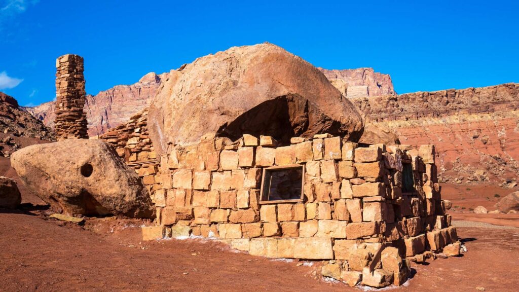
One of the latest additions to the list of Arizona National Monuments, Vermilion Cliffs, established in 2000, is known for its enormous, distinct and colourful sandstone rock formations, beautiful buttes and stunning slot canyons at the edge of remote, sandy plateau and cliffs rising from 3100 to 7100ft.
The area across Marble Canyon also has a rich history. It has been inhabited for more than 12,000 years, as suggested by the remains of some ancient Native American pueblos and fascinating prehistoric petroglyphs found throughout the plateau.
It is one of the most photographed destinations in the US, and if you seek solitude amidst a vast expanse of primarily unexplored wilderness, a visit to Vermilion Cliffs will take off-the-beaten travel to a new level.
RECOMMENDED – TOP 10 SPOTS TO WATCH A STUNNING SUNRISE IN SEDONA
The gorgeous cliffs with stunning stripes of white and orange and peaks offer some splendid views during sunset and sunrise.
There are three main attractions to explore in Vermilion – the Buckskin Gulch slot canyon, the rock formations of Coyote Buttes, including the Wave, and Lees Ferry, a small settlement along the Colorado River-Paria River confluence.
Coyote Buttes North, home of the Wave, is a must-stop, loved by photographers and nature lovers.
The Wave is a fascinating swirled sandstone formation that you can access via a 6-mile round-trip hike.
Unlike other Arizona national monuments that can be explored spontaneously, you’ll need to plan to visit Vermilion, as many areas require permits for camping and hiking.
Note that only 20 permits a day are given to visit The Wave.
Half are available through an online lottery, and you can obtain the other half from the visitor centre at Grand Staircase-Escalante national monument in Kanab, Utah.
To avoid the hassle, I recommend booking this excellent guided tour that starts from Page.
Also, check out the Vermilion Cliffs Condor Release Viewing Site to watch endangered California condors cruising overhead or on the cliffside.
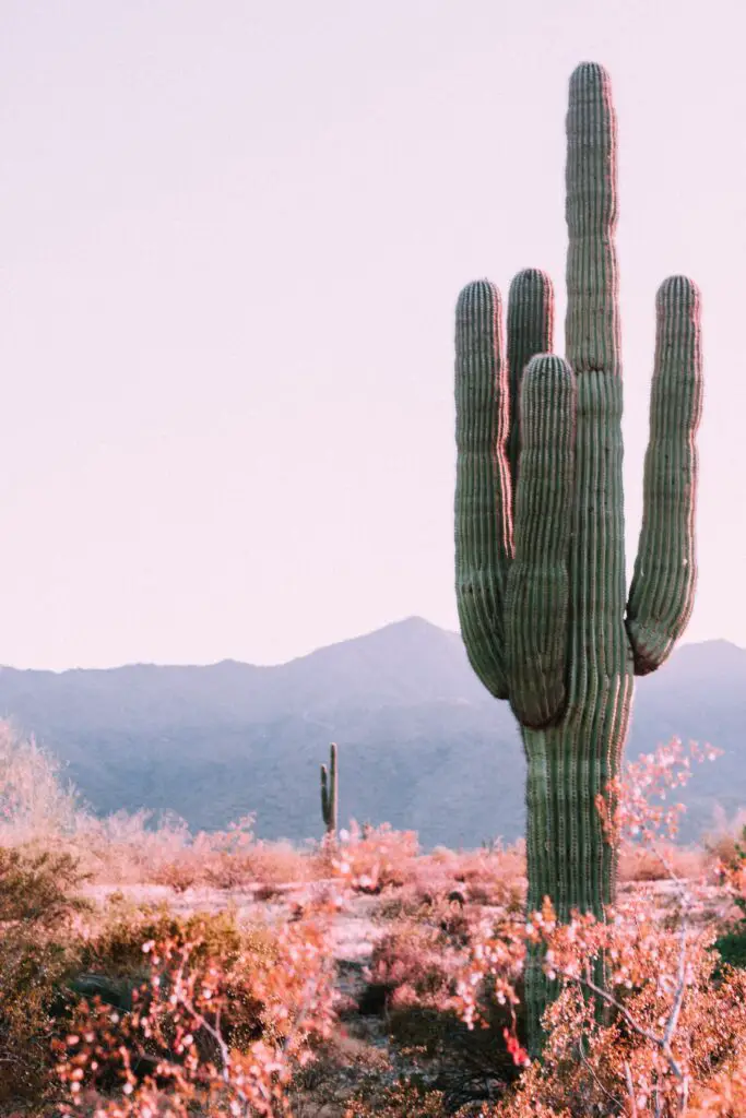
ORGAN PIPE CACTUS NATIONAL MONUMENT, AJO
- The nearest city – Tucson
- Famous for – Organ pipe cacti and a unique ecosystem of the Sonoran Desert
- Best time to visit – Spring and Fall
- Facilities – Visitor Center, RV and tent campsites, bookstore, backcountry camping, museum, restrooms
- Managed by – National Park Service
- Entry – $25 fee per adult, valid for seven days
If you have been to Saguaro National, one of the top national parks in Arizona, you will be surprised to see how similar it looks to the Organ Pipe Cactus National Monument.
Organ Pipe Cactus National Monument is one of the top Arizona National Monuments located in the extreme southern part of the state, sharing a border with the Mexican state of Sonora.
Organ Pipe Cactus is known for its magnificent Organ Pipe cacti, native to Mexico, covering over 516 square miles of untouched wilderness, with other dominant cacti being Saguaro.
It is the only place in the US where the senita and organ pipe cacti grow wild. Organ Pipe Cactus are fascinating plants and can live over 150 years old.
They produce their first flower when they are 35 years old. These fascinating and giant cacti bloom only at night in May and June and become bright red fruits in July.
It is also classified as a UNESCO biosphere reserve, home to unique desert wildlife and a popular bird-watching spot.
The monument encompasses diverse landscapes, from arid plain lands to surprisingly high mountains, with Mount Ajo topping out at 4,800 high.
Despite its rich and abundant terrain, it is one of the underrated national monuments in Arizona, receiving fewer tourists.
This varied landscape makes for excellent hiking opportunities, where you can also explore the remains of abandoned mines and their ancient cultures.
One of the best trails is the Bull Pasture hike, a three-mile round trip covering a part of Mount Ajo, offering spectacular bird views.
Driving around is the best way to wander in this monument, with the most popular drives are the 21-mile Ajo Mountain Drive and Puerto Blanco Drive which takes you through incredible and unique landscapes only found in Arizona.
One of the popular activities in Organ Pipe Cactus National Monument is camping in the desert. You can also enjoy backcountry camping.
Twin Peaks campground is popular, where you can set up your tent or RV among the giant cacti.
Night time is fascinating for watching the star-lit skies, surrounded by unique desert vegetation and mountains.
CASA GRANDE RUINS NATIONAL MONUMENT
- The nearest city – Phoenix, Tucson
- Famous for – Ancient historic site
- Best time to visit – Spring
- Facilities – Visitor Center, picnic grounds, guided tours
- Managed by – National Park Service
- Entry – Free admission
One of the popular day trips from Phoenix and Tucson is a visit to Casa Grande Ruins National Monument northeast of the city of Casa Grande, which preserves a group of Hohokam structures dating to the Classic Period.
This collection of ruins dating to the 14th century from an ancient farming community of Sonoran Desert Peoples, one of the most sophisticated communities known for their wide-scale irrigation farming and extensive trade connections, is one of the top Arizona National Monuments to learn about the settlers in Arizona many hundred years ago.
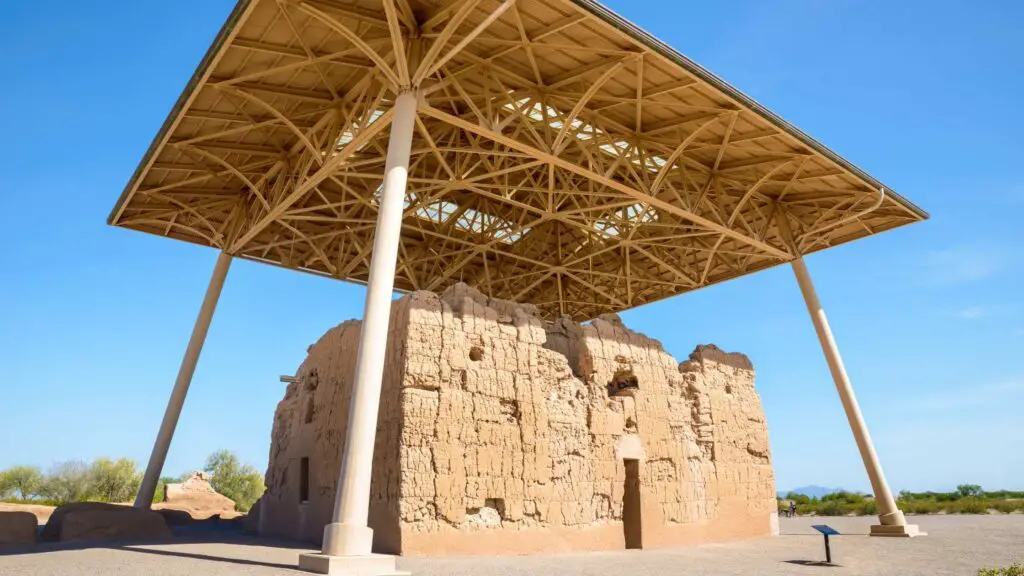
Archaeologists have classified the ruins as either a meeting place or a waypoint in a system of complex irrigation systems.
But since little documentation has been discovered so far, the complete history of the ruins remains a mystery.
Other highlights are an informative visitor centre, where you can learn about the Hohokam culture, a collection of Sonoran Desert plants and a shady picnic area.
UNDERRATED ARIZONA NATIONAL MONUMENTS
MONUMENT VALLEY NAVAJO TRIBAL PARK
- The nearest city – Flagstaff
- Famous for – filming location
- Best time to visit –
- Facilities – Visitor Center, museum, restrooms
- Managed by – National Park Service
- Entry – Covered by the ticket to Sun Crater monument
When you think of America’s Wild West, no landscape ever comes to perfectly symbolising it than the Monument Valley Navajo Tribal Park, which is one of the most famous filming locations in the US.
Located within the Navajo Nation Reservation, straddling the Arizona-Utah state borders, its dramatic desert landscapes are instantly recognisable.
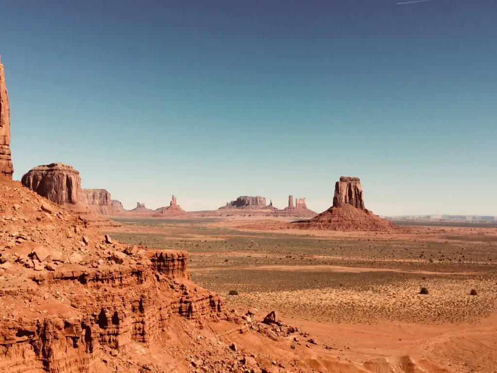
Although its cinematic fame may be why it is so popular, it is one of the least visited Arizona national monuments.
This fantastic landscape, known for dozens of spectacular free-standing sandstone buttes and monoliths towering above the sweeping sagebrush panoramas, is also home to ancient cliff dwellings.
Known to the Navajo as the ‘Valley Between the Rocks,’ it is one of the best places in Arizona for watching stunning sunsets and spectacular sunrises, and no wonder it draws thousands of photographers.
Like Canyon de Chelly, Monument Valley is on Navajo tribal land and still houses many families whose ancestors have lived here for centuries.
You’ll need to hire or book a jeep or high-clearance four-wheel-drive vehicle trip and pay an access fee to drive through the tribal park on a 17-mile dirt loop to experience everything in the park.
You can take one of the guided tours(check this fantastic one here)with a Navajo or Hopi person to Mystery Valley and Hunts Mesa to learn about the Puebloan history and culture.
For hikers, the 3.2-mile Wildcat trail around the West Mitten butte is one of the best to explore without a guide. There is no camping within the park itself.
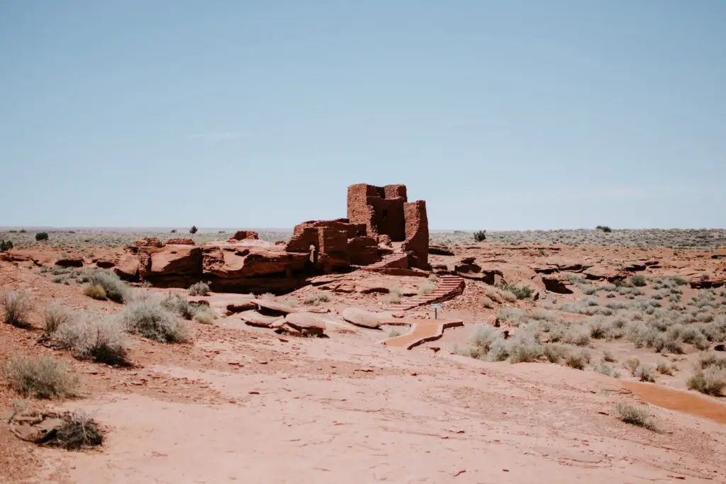
WUPATKI NATIONAL MONUMENT, FLAGSTAFF
- The nearest city – Flagstaff, Arizona
- Famous for – The 12th-century desert pueblos
- Best time to visit – Spring
- Facilities – Visitor Center, museum, restrooms
- Managed by – National Park Service
- Entry – Covered by the ticket to Sun Crater monument
One of the famous Arizona national monuments is located north of Flagstaff in the north-central part of the state.
Located next to Sunset Crater, Wupatki National Monument is a fascinating place encompassing a staggering series of archaeological sites and centuries-old settlements built by the Ancient Pueblo People.
You can explore the ruins in a few hours, completing a few hikes.
You can add a visit to Wupatki as one of the day trips from Flagstaff or combine it with a visit to the neighbouring Sun Crater, where camping is available.
Waupatki National Monument, known for being home to the ancient Anasazi or Pueblo people, comprises ruins of five red pueblo ruins dating to the 12th century, built from slabs of the region’s brick-red Moenkopi sandstone in the open grasslands symbolising the Sinagua and Anasazi cultures,
The pueblo is the ancestral remains of a Hopi Indian village, built by the Hisatsinom people, who are ancestors of today’s Hopi tribe.
The area was a farming community and was one of northern Arizona’s most densely populated areas since around 500 AD.
The violent eruption of the nearby Sunset Crater Volcano around AD 1085 forced people to relocate to a new area as ash was spread over 800 square miles of land.
The sites were abandoned, with almost 2,700 buildings of bright red rock dwellings left behind.
Visitors can go inside the 900-year-old Wukoki Pueblo, the monument’s main attraction and the largest structure in the park.
This structure had over a hundred rooms and a ball court on show.
You can reach Wukoki Pueblo by a half-mile round-trip walk on a paved pathway.
Enjoy the gorgeous views over the Painted Desert and nearby San Francisco peaks from the trail.
Don’t miss the short hike up to Citadel Pueblo, atop a steep hill offering splendid views of the distinct desert’s wilderness.
RECOMMENDED GUIDED TOUR
From Sedona or Flagstaff: Ruins & Volcanoes Small-Group Tour
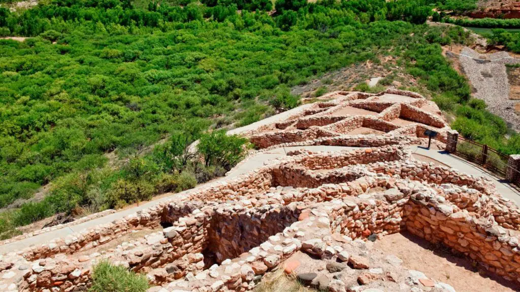
TUZIGOOT NATIONAL MONUMENT
- The nearest city – Flagstaff
- Famous for – 1000-years old Sinagua pueblo
- Best time to visit –
- Facilities – Visitor Center, museum, picnic grounds, restrooms
- Managed by – National Park Service
- Entry – $10 fee for 16 years and older
Tuzigoot National Monument is one of Arizona’s national monuments that does not get the attention it should.
Located in north-central Arizona 40 miles southwest of Flagstaff, most people miss going from Flagstaff to Tuzigoot National Monument.
Stop at this beautiful monument if you plan to travel to Clarkdale and Cottonwood towns.
The park is open year-round and is known for the thousand-year-old ruins of a pueblo built by the Sinagua people, which housed over five hundred people across its 110 rooms.
Archaeologists believe the structure was built about 1000 AD and gives glimpses of the Sinagua peoples, including their culture that flourished in the Verde Valley nearly 1,000 years ago.
Unlike the other national monuments in Arizona, primarily cliff-dwelling sites belonging to the other Indigenous tribes, Tuzigoot National Monument is a hilltop dwelling site.
This rustic stone pueblo remains perched on a ridge overlooking the Verde River.
The Visitor Center houses a museum displaying the artefacts excavated from the site, which gives insights into the lives of the ancient people.
ARIZONA NATIONAL MONUMENTS FOR OFFBEAT TRAVEL
GRAND CANYON PARASHANT NATIONAL MONUMENT
- The nearest city – Flagstaff
- Famous for – Beautiful landscapes, backcountry camping, off-roading
- Best time to visit – Fall and Spring
- Facilities – Visitor Center, museum, restrooms
- Managed by – National Park Service
- Entry – Free admission
Often overshadowed by the more prominent and world-famous Grand Canyon National Park, Parashant National Monument is one of the beautiful offbeat Arizona National Monuments worth visiting for many reasons.
Apart from very few tourists, the monument encompasses million square miles bordering the Grand Canyon in the north and spreading between Utah and Nevada, on the north side of the Colorado River, bordering Lake Mead N.R.A.
Parashant encompasses thousands of acres of rugged lands around the canyons, packed with washes, mountains, rock formations and desert vegetation.
Since it is a backcountry monument, it’s not as easy to access, which is why it has remained an offbeat destination.
You’ll need to plan ahead and only travel on a high clearance 4×4 vehicle to explore its beautiful scenic drives, some of which will take you through southern Utah and to many spectacular Grand Canyon overlooks.
Other sites include dormant volcanoes, Native American petroglyphs, cattle and cowboy line shacks, and historic schoolhouses.
If you want to know more, visit the information centre in St. George, Utah, before embarking on your drive.
Cell phone service, paved roads, and basic amenities carry food, water and a tank full of gas.
Due to its fantastic location far from civilizations and busy cities, it is one of the most popular destinations in the USA for stargazing.
The spectacular clear skies make it a Gold-tier destination from the International Dark-Sky Association.
AGUA FRIA NATIONAL MONUMENT
- The nearest city – Phoenix
- Famous for – Historic ruins and hiking trails
- Best time to visit – Spring and fall
- Facilities – None. Carry water and snacks
- Managed by – The Bureau of Land Management
- Entry – Free admission
Located in Central Arizona, about 40 miles north of Phoenix is one of the best offbeat Arizona National monuments.
Agua Fria is a 70,000-acre monument with elevations in the landscape varying from 2000 to 4600 feet, comprising a high elevation desert with grassy mesas, and prominent and deep canyons along the Agua Fria River, flowing through saguaro-covered cliffs, which are the main attractions.
a wide variation in wildlife and vegetation, including the famous saguaro cactus forests at lower altitudes, and ancient Indian relics, giving rich insights into the former inhabitants of this site.
You can also explore the stone masonry remains of Pueblo la Plata, a prehistoric site and many old mines.
Due to its remote location and rugged landscapes, most attractions can only be reached by high-clearance vehicles or hiking.
PIPE SPRING NATIONAL MONUMENT
- The nearest city – Kanab
- Famous for – Mormon and Native American history
- Best time to visit – Summer and Spring
- Facilities – Visitor Center, ranch, museum, restrooms
- Managed by – National Park Service
- Entry – $10 per person admission fee for those 16 and older
One of the offbeat Arizona national monuments is Pipe Spring National Monument, located in the northwestern part of the state near Utah, 20 miles southwest of Kanab.
Pipe Spring National Monument is one of the least well-known of all national monuments and parks in Arizona, thanks to its remote location and its trendy neighbour, the Grand Canyon.
Pipe Spring National Monument, located on the Kaibab-Pauite Indian Reservation off AZ 389, is known for its American Indian, an oasis, and Mormon pioneer history.
Hundreds of years old, the water found at the desert oasis in the park supported life dating back to the Ancestral Puebloans and Kaibab Paiute Indians.
When Mormon settlers discovered the freshwater oasis at Pipe Spring, the arrival of the newcomers caused conflict between the Native Americans (the Kaibab Paiute) and Mormons.
Start your exploration by visiting the Kaibab Band of Paiute Indians Visitor Center, where you can learn about the monuments, get details of the guided talks by the rangers and historians, guided hiking tours, and physical maps.
Check out a well-preserved 1870s Mormon fort; cabins, an orchard and gardens can be found here, best explored on tour.
You can glimpse oasis life at Pipe Spring National Monument at their museum, offering live demonstrations, including “living history” demonstrations during summer.
Hike the ridge trail, a half-mile trail that will take you back in time to the American Indian and pioneer life in the Old West.
Tour the historic Mormon homestead and farm, where you can buy fresh produce.
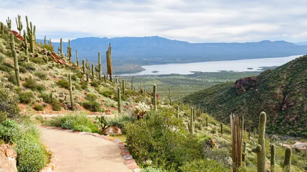
TONTO NATIONAL MONUMENT
- The nearest city – Flagstaff
- Famous for – Ancient cliff dwellings
- Best time to visit – Summer and Spring
- Facilities – Visitor Center, picnic grounds, museum, guided tours, restrooms
- Managed by – National Park Service
- Entry – $10 fee for visitors 16 years and older
Tonto National Monument is an excellent destination if you are looking for Arizona National Monuments rich in ancient history.
You can easily plan a day trip from Phoenix, as Tonto National Monument is located in central Arizona, approximately 45 miles northeast of Phoenix and is open year-round.
Tonto National Monument is known for the Salado community that inhabited this region about 700 years ago, blending with many Native American cultures.
They are known to have constructed sophisticated cliff dwellings, two of which constitute the main attractions of Tonto National Monument.
The buildings, dating from around 1300 AD, are located in a rocky, cactus-covered area on the west side of state route 188, atop a hill overlooking Theodore Roosevelt Lake on the Salt River, and are divided into sites.
Unlike the other cliff dwellings in Arizona that can only be seen from afar, you can get into these incredible structures at tonto, allowing you to explore and appreciate them up close.
The primary way to explore Tonto National Monument is by hiking to the Lower Cliff Dwelling via a half-mile hike on a paved path beginning at the visitor centre.
You will go up the side of the hill overlooking beautiful views of the lake and basin below.
The Upper Cliff Dwelling is only accessible during the winter on guided tours by park rangers for a 3-mile round-trip hike.
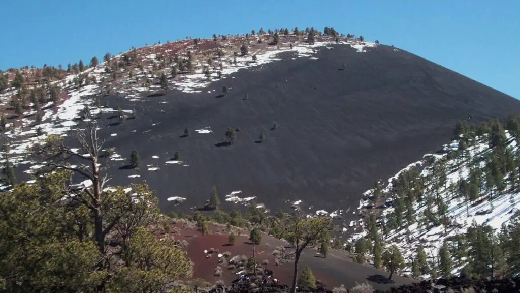
SUNSET CRATER VOLCANO NATIONAL MONUMENT
- The nearest city – Flagstaff
- Famous for – The remains of an ancient volcano
- Best time to visit – Spring
- Facilities – Visitor Center, restrooms, picnic grounds, campgrounds
- Managed by – National Park Service
- Entry – $25 fee per person covers access to Sunset Crater Volcano National Monument and Wupatki National Monument and is valid for seven days.
Just a short distance from Flagstaff in north-central Arizona is a fantastic world of volcanoes, lava tubes, and cinder cones.
One of the offbeat Arizona national monuments, Sunset Crater Volcano National Monument, is home to the Sunset Crater, the youngest of over 600 volcanoes that make up the San Francisco Peaks.
In this national monument rising above the foothills and lava fields surrounding it, you can view the dramatic jet-black lava flows and towering cinder cones of Sunset Crater, an extinct volcano with shades of red, orange and yellow that erupted about 1,000 years ago. It last erupted in 1085 that transformed the landscapes completely.
To see the full spectrum of volcanic activity at the monument, hike the Lava’s Edge Trail through the jagged coal-coloured basalt of the Bonito lava flow, then continue to the Lava Flow Trail, which takes you along fascinating landscapes at the base of the volcano below cinder fields.
It’s impossible to climb to the top of Sunset Crater as it’s been closed since 1973 to protect it from erosion.
But you can also make it to the top on a one-mile trail up 7,250-foot Lenox Crater, the park’s more miniature volcano offering spectacular views of Sunset Crater and the surrounding Bonito lava flow. You can also camp, and check out roadside viewpoints.
NAVAJO NATIONAL MONUMENT
- The nearest city – Flagstaff
- Famous for – Ancient cliff dwellings
- Best time to visit – Fall and Spring
- Facilities – Visitor Center, bookstore, guided tours by rangers, hiking trails, museum, restrooms
- Managed by – National Park Service
- Entry – Free admission
Not to be confused with the iconic Monument Valley, Navajo National Monument is one of the best Arizona National Monuments for offbeat outdoor travel in the state.
The monument was established to preserve three well-preserved cliff dwellings dating to the early 14th century of the Ancestral Puebloan people: Keet Seel, Betatakin, and Inscription House, the inhabitants of the Navajo Nation region, also known by other names.
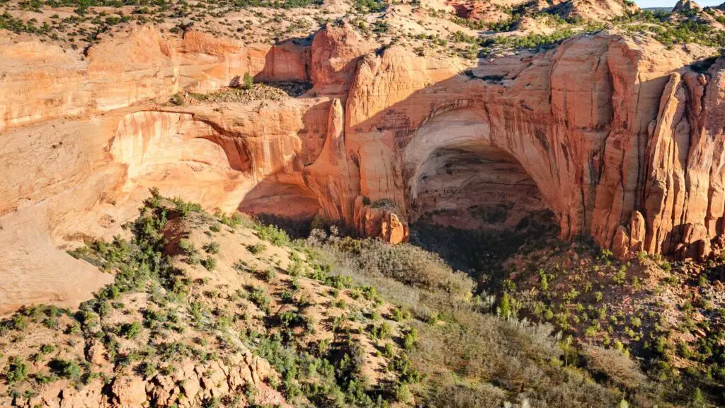
Navajo National Monument offers you to see ancient cliff dwellings up close surrounded by spectacular desert sandstone landscapes on guided hiking tours by the National park service rangers. You need to book your spot for the tour in advance.
Note that hiking is moderately strenuous and even challenging, apart from being longer. The trail to Betatakin takes 3 to 5 hours of hiking over steep terrain.
The trail to remotely located Keet Seel is 17-miles long round trip. Camping is also available near the trailhead.
IRONWOOD FOREST NATIONAL MONUMENT
- The nearest city – Tucson
- Famous for – Historic sites and hiking trails
- Best time to visit – Fall and Spring
- Facilities – None. Pack all the essentials
- Managed by – The Bureau of Land Management
- Entry – Free
One of the offbeat Arizona National Monuments known for its untouched wilderness, settlements dating to over 500 years, and rich wildlife is Ironwood Forest National Monument, located near Tucson near the Saguaro National Park.
Ironwood Forest National Monument, established in 2000 to conserve the natural abundance and historic sites, encompasses 180,000 acres of land, 59,000 acres of which remains under private lands.
Besides Ironwood trees, the monument conserves many native endangered animals and plants.
There are hiking trails leading to three ancient archaeological sites, The Los Robles Archeological District, the Mission of Santa Ana del Chiquiburitac and the Cocoraque Butte Archaeological District, dating between 600BC and 1400AD, surrounded by stunning landscapes and mountain views.
The monument also contains a working copper mine and many ghost towns you can drive by.
Note that there are basic facilities. Make sure to carry all you need when visiting this monument.